No Strings on This Apron
GNSS technology helps turn nearly 30 acres of Hurlburt Field wetlands into prime parking space for newly arriving aircraft.

Dwarfed by the adjacent Eglin Air Force Base (the world’s largest airbase) and nowhere near as famous as nearby Pensacola Naval Air Station (home to the world-famed Blue Angels), Hurlburt Field in Ft. Walton Beach, Florida is nonetheless a key component in our national defense structure. Serving as the headquarters of 1st Special Operations Wings as well as the Air Force Special Operations Commands, the field is host to a broad range of mission-specific support aircraft, including the MC 130H Combat Talon II, the tilt-rotor CV-22 Osprey, the U-28A Draco, MQ-9 Reaper unmanned aerial vehicles, the C-146 Wolfhound and the occasional C17 and C5. The impending arrival of twenty-one new AC-130J Ghostrider aircraft, however, has prompted the need for a $30 million expansion of the Field’s apron area to accommodate them. The task of doing so fell to Mississippi-based RC Construction (RC), one of the country’s foremost specialists in airport/runway construction. Tapping the strengths of both digital technology and stringless GNSS paving, the company turned one of the most challenging scenarios it’s faced into a walk in the Field.
Pressing Business
While building an apron capable of supporting a squadron of massive combat aircraft is in the wheelhouse of many heavy civil contractors, doing so in the midst of a wetland area is not. Only a handful of companies possess that level of expertise — RC being one of the leaders. According to Edward Murchison, RC’s chief and quality control manager, initial work on what would be called CAPA (Combat Aircraft Parking Area) South started in June 2020.
“The project is divided into two separate contracts: CAPA South and CAPA North and both demand the same approach,” he said. “The south portion of the project started in June 2020 with a clearing operation to remove trees and vegetation from the prospective apron area. With the area cleared, one of our subcontractors came in to lay a mat of geogrid designed to stabilize the area — both the material below and the sand, which gets placed on top of it.”
The multiple lifts of sand and geogrid — as well as the settling plates set upon the final lift — are part of a surcharge process, which will essentially displace the water and stabilize the soil making it suitable for paving. Not surprisingly, the volume of material demanded for such a process is massive.
“CAPA South took more than 40,000 truckloads — about a half million tons — of sand to surcharge that area,” said Murchison. “And we anticipate the same to be true for the north facet of the job. Once we’ve placed the specified depth of material, which can be as much as 10’ of sand, and installed the settling plates, we use a digital level to monitor the settling process.”

“On a project like this in which accuracy and production are key, going with the Millimeter GPS solution, which eliminates the need for both grade stakes and stringline, just made sense."

Small but Mighty
That innocuous Topcon DL-502 digital level Murchison references is also his choice as the unsung hero of the CAPA South surcharge operation — a bit ironic since it operated in the midst of a host of highly-complex GNSS instruments.
“After thirteen settling plates were set, that level initially took measurements every day,” he said. “The measurements were critical in determining when the marsh was considered stable enough for construction. That digital level was the star in that part of the operation, for sure.”
Once the geotechnical engineering team determined that settling had, in fact, ceased — Murchison said the process for the south CAPA took more than a year — they removed the surcharge, graded the area in advance of a one-foot thick graduated aggregate base course (GABC) and began paving.
Pick a Lane
The south portion of the apron at Hurlburt is being paved in 21 individual sections or lanes, which measure 19’ 4” wide and 904’ long. Each lane will be 15” thick, heavily reinforced with large-size rebar and contain roughly 880 cu. yds. of concrete which, while sizeable, is far from challenging for RC, according to Murchison.
“We recently did a project at Pope AFB in North Carolina in which we removed and replaced the entire runway in 120 days,” he said. “On that project, we were placing around 3,200 cu. yd. of concrete, more than 320 trucks worth, per day. We have the people and equipment to make the workflow smooth and efficient.”
Established in 1986, RC Construction Co., self-performs a range of services including concrete placement/paving, demolition, grading, drainage, and base course installation. Their specialties in airport infrastructure work include airfield platforms and systems, hangars, transport roads, runways, taxiways, and aprons.
“The work we’re doing here at Hurlburt is really our forte, probably representing about 90% of the projects we do, so we are well-equipped to handle it,” added Murchison.
No Stakes, No Strings
Both to meet the tight specifications demanded for the project and because of their long-time belief in the benefits of GNSS technology, RC eschewed the use of stringline for the lane pours at Hurlburt, opting instead for Topcon Millimeter GPS. According to Murchison, going that route was literally a no-brainer for the company.
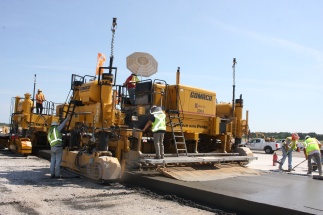
“RC has been a user of Topcon GPS machine control for about 11 years now,” he said. “Our confidence in the technology is evident everywhere here. We used it — and continue to use it — on graders and dozers working the surcharge operation. We used it to lay down and clip the GABC. We use it on our excavator digging utility trenches for the project. And we currently have machine control guiding the tracking of the GOMACO PS-2600 placer/spreader we are using to feed the paver. So, on a project like this in which accuracy and production are key, going with the Millimeter GPS solution, which eliminates the need for both grade stakes and stringline, just made sense.”
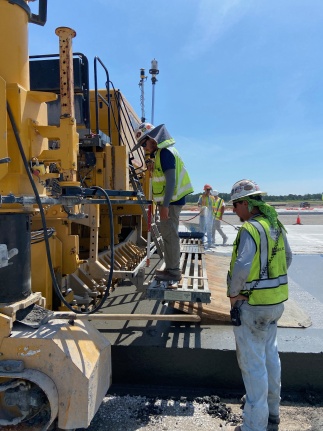
RC’s millimeter-grade GNSS paving solution begins with a series of Topcon PZL-1 laser transmitters positioned at established reference points adjacent to the apron lanes, each transmitting a “laser-zone” of vertical data to a pair of Topcon PZS-MC sensors mounted on the company’s GOMACO GP-4 slipform paver. Using that information, Millimeter GPS sets the necessary height of the paver, and dramatically tightens vertical accuracies. That proved ideal for RC’s needs at Hurlburt. Even though specs demanded finished grade tolerances of ±1/2”, Murchison said they were typically paving within ±1/8”.

“We recently did a project at Pope AFB in North Carolina in which we removed and replaced the entire runway in 120 days,”

Stepping Out
The degree of control and accuracy provided by the millimeter-grade solution was particularly effective, given the two-foot drop in elevation for drainage from the western side of the apron to its eastern edge. To tie the individual lanes together, RC used a paving method called “step & slip” which, rather than simply paving every other lane, then filling in the gaps, called for three pilot lanes to be created, then adjacent lanes poured off of those.
“Using step and slip, in which one track of the paver is up on a finished lane and the other is at grade, was my brother Scott’s idea,” said Murchison. “He felt that doing the three pilots and then using the step and slip approach for the balance of the lanes would produce a better grade across the apron. Because he’s done this so many years more than I have, I deferred to his decision — and that definitely turned out to be the case. When we tested those joints, there was no light between them — the blending is seamless.”
Because of the length of the lanes on the Hurlburt project, RC is using a “paving train” which consists of the spreader at the front, the paver, and a Spanit 4000 work bridge at the rear. The spreader takes material from 10-yard end-dumps onto a loading conveyor, which places it in front of the unit. Then, using a horizontal auger, the mounded concrete is uniformly spread — both laterally and vertically — on the lane.
“Doing that helps ensure the concrete “head” in front of the paver is also uniform, which enhances both production and smoothness,” said Murchison. “The work bridge provides the final touch in the paving operation, creating a burlap drag finish on the apron’s surface.”
It's in the Mix
As one might imagine, the concrete mix design for a project of this caliber is both hearty and quick setting. Delivered from a 120-cu. yd./hr. batch plant erected directly across the airfield, the mix is comprised of #4-stone, #67-stone, and sand, with air entrainment and water reducers added.
“In terms of setup time, this 3,000 psi mix design has just been off the charts,” said Murchison. “Only three or four days after placement, it is already at 2,500 psi, which is great because it allows us to get on it to address coring points, drive on it if needed, etc. It’s really worked to our favor in helping keep production levels up.”
The full scope of RC’s work taking place at Hurlburt also includes installation of storm drainage, subdrainage, water, sewer, force main, as well as prepping for electrical distribution and communications. And, as mentioned, RC Construction’s belief in GNSS technology is playing a role in nearly every facet of the job.
“Our commitment to Topcon machine control is strong and it’s based on the results we’ve gotten from it over the years,” said Murchison. “So, tapping the stringless paving solution for this job was literally a no-brainer. The production is there, the accuracies are there, the ability to provide a safer work environment is there — the benefits speak for themselves.”


