
Rovers and Base stations
GNSS receivers for your survey and construction positioning applications
“All-in-view” satellite tracking for GPS, GLONASS, GALILEO, BeiDou, and QZSS constellations
“All-in-view” satellite tracking for GPS, GLONASS, GALILEO, BeiDou, and QZSS constellations
Base stations and rovers for positioning on the move
GNSS receivers are the backbone of any base and rover setup. Choose from receivers designed for semi-permanent mounting or others that can quickly screw to the top of a tripod or range pole.

Survey and construction uses
HiPer receivers are a popular choice for survey applications, including property boundaries, engineering design, and cadastral projects. These versatile tools are also often used for construction site layout/stakeout, grade checking, and material volume calculations. HiPer receivers can also be paired with robotic total stations for Hybrid Positioning™.
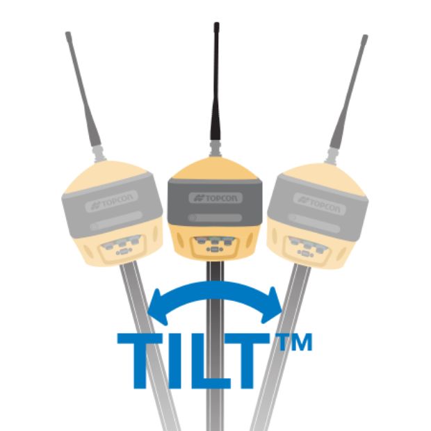
TILTTM for hard-to-reach measurements
Measure building edges without using an offset, or stretch to otherwise out-of-reach points using Topcon Integrated Leveling Technology (TILT). A 9-axis inertial measurement unit (IMU) paired with a digital compass allow the HiPer HR and VR receivers to compensate for rods that are not exactly vertical.

Universal Tracking ChannelsTM technology
Topcon-patented Universal Tracking Channels technology efficiently identifies and uses “all in view” GNSS satellite constellations and signals – automatically optimizing reception.
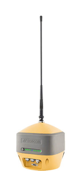
HiPer HR
Receiver with integrated
antenna and radio
Description
Measurement, layout, field survey, grade checking, base or rover, Hybrid positioning™️,TILT, network caster
Ideal use
GPS
GLONASS
BeiDou
Galileo
SBAS
QZSS
IRNSS
Constellations tracked
UHF radio
FH915+ spread
spectrum radio
LongLink™️
Bluetooth®️
4G Cell (Europe)
WI-FI
L-band
Communications for
corrections (availability
varies by region)
Yes
Hybrid Positioning
Hot-swappable battery
Battery
-40°C to 65°C
Operating temperature
IP67
Dust and water resistance
115 mm x 115 mm x 132 mm
Dimensions
1 kg
Weight
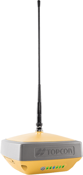
HiPer VR
Receiver with integrated
antenna and radio
Description
Measurement, layout, field survey, grade checking, base or rover, Hybrid positioning™️, TILT
Ideal use
GPS
GLONASS
BeiDou
Galileo
SBAS
QZSS
IRNSS
Constellations tracked
UHF radio
FH915+ spread
spectrum radio
LongLink™️
Bluetooth®️
4G Cell (Europe)
L-band
Communications for
corrections (availability
varies by region)
Yes
Hybrid Positioning
Double-internal batteries
Battery
-40°C to 65°C
Operating temperature
IP67
Dust and water resistance
150 mm x 100 mm x 150 mm
Dimensions
925 g
Weight

HiPer SR
Receiver with integrated
antenna
Description
Measurement, layout, field survey, grade checking, base or rover, Hybrid positioning™️
Ideal use
GPS
GLONASS
Constellations tracked
LongLink™️
Bluetooth®️
Communications for
corrections (availability
varies by region)
Yes
Hybrid Positioning
Internal battery
Battery
-40°C to 65°C
Operating temperature
IP67
Dust and water resistance
150 mm x 150 mm x 64 mm
Dimensions
850 g
Weight
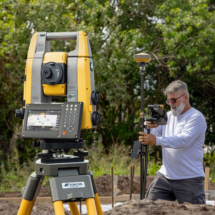
Stay connected via line of sight and GNSS/GPS
Hybrid Positioning™ technology combines GNSS (sometimes called GPS) positioning and optical robotic measurements on one rover pole. Finish projects quickly and accurately by easily switching between prism- and satellite-based measurement modes when you lose line-of-sight or satellite reception, or as you encounter other jobsite challenges.
Establish a solid base for your network
NET-G5 or MR-2 receivers can be used with an external GNSS antenna to create a continuously operating local base station.
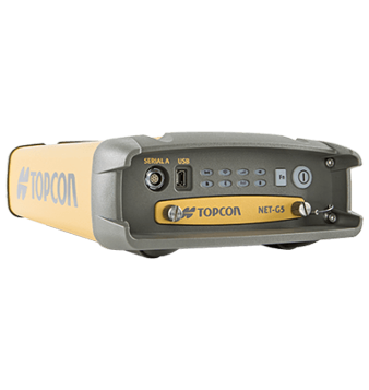
NET-G5
Modular receiver
Description
Continuously operating reference station (CORS),
local base station, network caster
Ideal use
GPS
GLONASS
BeiDou
Galileo
SBAS
QZSS
IRNSS
Constellations tracked
External radio ports Ethernet WI-FI L-band
Communications for corrections (Availability varies by region)
Internal battery
Battery
-40°C to 80°C
Operating temperature
IP67
Dust and water resistance
40 mm x 55 mm x 10 mm
Dimensions
< 2 kg
Weight
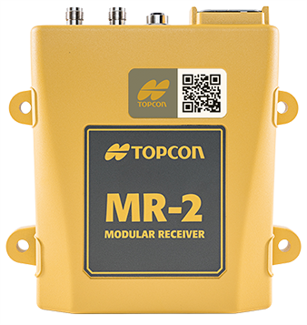
MR-2
Modular receiver
Description
Local base station, i.e. for
larger construction sites
Ideal use
GPS
GLONASS
BeiDou
Galileo
SBAS
QZSS
IRNSS
Constellations tracked
External radio ports Ethernet L-band
Communications for corrections (Availability varies by region)
---
Battery
-40°C to 80°C
Operating temperature
IP67
Dust and water resistance
40 mm x 55 mm x 10 mm
Dimensions
0.95 kg
Weight
Boost RTK connectivity and performance
MAGNET Relay is a GNSS correction service that extends RTK (Real-time Kinematic) coverage using cellular connectivity. It is designed for situations where traditional broadcasting methods are not feasible, enabling efficient RTK correction for up to 10 rovers from a single base, while doubling the broadcast distance.

Prefer to skip base station set ups?
Topnet Live global GNSS correction services enable your projects with reliable, high-precision accuracy for survey, machine control and more without a base station.
Get support where and when you need it-
for all your Topcon products.
Online Support
A simple, free login entitles you to the following benefits:
- Downloadable product manuals
- Video tutorials and quick guides
- Comprehensive training and documentation
Extend Your Benefits
Register your product now to receive additional support including:
- Software and firmware updates
- Product-specific notifications
We've Got You Covered
Need more info?
We can email you additional product information. Your contact information will never be shared.
See it in action
Your local dealer can't wait to show you what we can do for your business.
Zoetermeer Netherlands
https://www.topconpositioning.com/#dealerModal
©2025, Topcon Positioning Systems, Inc.